

September 8, 2020, Vancouver, Canada – Jaxon Mining Inc. (TSXV: JAX, FSE: OU31, OTC: JXMNF) (“Jaxon” or the “Company”) is pleased to confirm the existence of a third artisanal workings site at Netalzul Mountain. The historical site at NATMR006 was previously documented in BC Geological Survey Assessment Report #32043 (2010), and reported assay results of > 10,000 ppm Cu, > 10,000 ppm Pb, > 100 ppm Ag, 2597.9 ppb Au and > 2000 ppm Sb. Historical samples were taken from the contact/fault-controlled shear zone.
Upon discovery, the field team re-mapped and re-sampled the area around the historical workings (Figure 2). Samples were analyzed with an XRF analyzer before being bagged for transport to the assay lab. The team identified the contact zone, and XRF results confirmed the presence of high-grade polymetallic mineralization. The grades indicated by the XRF analysis are consistent with the high-grade polymetallic mineralization occurrences previously reported in 2010. The mineralization appears to be structurally controlled by the large contact/fault shear zone between the Jurassic Bowser Lake hornfels and the Blunt Mountain granite intrusive (Figure 3). The massive sulfides minerals identified in the area include sphalerite, galena, wurtzite, tetrahedrite, chalcopyrite, pyrite and molybdenite (Figures 4-7). Further work continues, including mapping and sampling along the contact/fault/shear zone that marks the historical workings.
A Thermo Scientific Niton XL3t GOLDD+ XRF Analyzer was used to test the NATMR006 area samples for detectable levels of metallic elements including Ag, Cu, Zn, Pb, Mo, W, and Sb (results in Table 1).
Results from the XRF analysis and surface prospecting work confirm the existence (assay results pending) of a third high-grade polymetallic mineralized zone at Netalzul Mountain AOI.
Highlights of the results of the XRF analysis of samples taken from the contact/shear zone:
- The August 2020 samples taken from the NATMR006 area exhibited grades from multiple testing spots (assay results pending) of up to 1.4% Cu, 7.0% Pb, 13.4% Zn, 2257 g/t Ag, 1.1% Sb and 0.19% W (Table 1, Figure 1).
- Grades from six testing spots from an over 1.5 metre chip sample (Figure 5) from hornfels outcrop at the artisanal workings area, and within the contact/fault shear zone, are up to 0.97% Cu, 2.36% Pb, 2.79% Zn, 1510 g/t Ag, 0.74 % Sb and 0.16 % W (Table 1, Figure 1).
- Soil samples (A0027716, A0028753 and A0028772) testing results show strong polymetallic anomalies (Cu, Pb and Zn) within the contact/fault shear mineralization zone (Table 1, Figure 1).
- Sulfides mineralization in the hornfels within the contact shear zone extends up to seven metres (Figure 2). Sulfide minerals such as sphalerite, galena, wurtzite, tetrahedrite, pyrite and chalcopyrite are identified in the hornfels zone.
- Well-developed disseminated, veinlets and fracture filling sulfides minerals including chalcopyrite, pyrite, molybdenite and tetrahedrite minerals, have been identified in the granite (Figures 6-7) within the contact/fault shear zone. The mineralization in the granite is up to 5 metres from the contact (Figures 2, 6).
- The contact/fault shear mineralization zone is up to 12-20 metres wide and 1000 metres long (Figures 2, 3).
Table 1. Major Mineral Elements from Rock/Soil Samples within Contact/Fault Shear Mineralization Zone and Surrounding Areas using XRF Analyzer (final assay results pending)
| SAMPLE | Type | UTM_E | UTM_N | No. of Testing Spots | Cu_ppm | Pb_ppm | Zn_ppm | Ag_ppm | Sb_ppm | Mo_ppm | W_ppm |
| A0027509 | grab, hornfels | 626581 | 6130075 | 4 | 7221 | 18023 | 10673 | 971 | 4029 | 47 | 1906 |
| A0020737 | 626581 | 6130075 | 9 | 1204 | 70273 | 126552 | 133 | 604 | 11 | 1468 | |
| A0020738 | 626581 | 6130075 | 11 | 14202 | 40209 | 133526 | 2257 | 11486 | 12 | 1761 | |
| A0020740 | Chip, hornfels | 626591 | 6130072 | 6 | 9746 | 23571 | 27860 | 1510 | 7425 | 0 | 1636 |
| A0020741 | 626591 | 6130072 | 4 | 73 | 11 | 97 | 0 | 14 | 0 | 0 | |
| A0020742 | 626591 | 6130072 | 3 | 335 | 104 | 62 | 0 | 6 | 0 | 0 | |
| A0020743 | 626603 | 6130072 | 5 | 209 | 109 | 139 | 0 | 57 | 28 | 2227 | |
| A0020744 | 626603 | 6130072 | 7 | 431 | 241 | 813 | 0 | 21 | 46 | 17 | |
| A0020745 | Chip, granite | 626603 | 6130072 | 7 | 255 | 38 | 38 | 0 | 2 | 208 | 0 |
| A0020746 | 626603 | 6130072 | 8 | 671 | 591 | 48 | 0 | 61 | 1553 | 0 | |
| A0020747 | 626603 | 6130072 | 7 | 157 | 174 | 49 | 0 | 0 | 558 | 0 | |
| A0020739 | 626590 | 6130068 | 5 | 222 | 2 | 50 | 0 | 0 | 5 | 376 | |
| A0027715 | Soil | 626629 | 6130125 | 1 | 53 | 11 | 64 | 0 | 0 | 6 | 0 |
| A0027716 | Soil in contact zone | 626602 | 6130070 | 1 | 660 | 82 | 411 | 0 | 0 | 16 | 0 |
| A0028753 | 626565 | 6130068 | 1 | 400 | 689 | 2252 | 0 | 0 | 14 | 0 | |
| A0028772 | 626454 | 6129946 | 1 | 1287 | 40 | 197 | 0 | 0 | 25 | 25 | |
| A0027717 | Soil | 626609 | 6130028 | 1 | 0 | 0 | 13 | 0 | 0 | 7 | 0 |
| A0028751 | Soil | 626676 | 6130018 | 1 | 0 | 15 | 19 | 0 | 0 | 21 | 0 |
| A0028752 | Soil | 626569 | 6130108 | 1 | 0 | 0 | 22 | 0 | 0 | 3 | 0 |
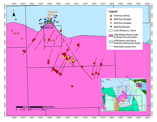
Figure 1. 2020 Rock and Soil Sampling Location Map, Netalzul Mountain AOI, Hazelton Property
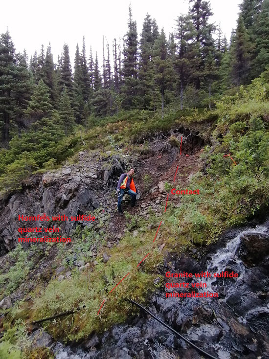
Figure 2. Historical Contact/Fault Controlled Shear Zone with Polymetallic Sulfides Mineralization at NATMR006, Netalzul Mountain
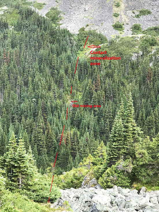
Figure 3. Historical Workings Site within a Large Contact/Fault Shear Zone at NATMR006, Netalzul Mountain
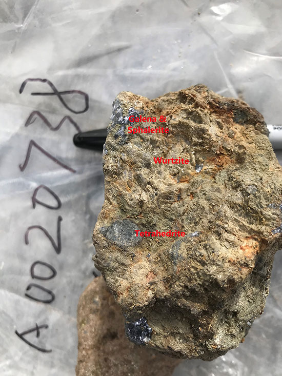
Figure 4. Rock sample from historical ore piles at artisanal workings showing massive sulfide minerals (galena, sphalerite, wurtzite and tetrahedrite) at NATMR006, Netalzul Mountain
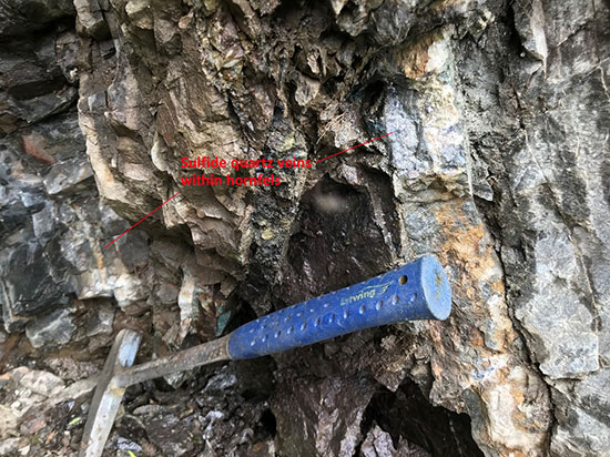
Figure 5. Sulfide (massive) quartz veins in hornfels within the contact/fault shear zone at NATMR006, Netalzul Mountain
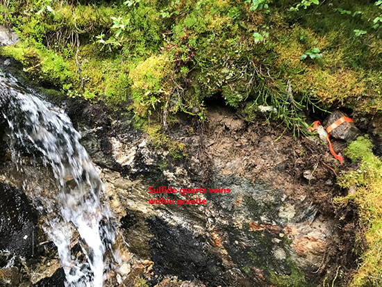
Figure 6. Sulfide quartz veins in granite within the contact/fault shear zone at NATMR006, Netalzul Mountain
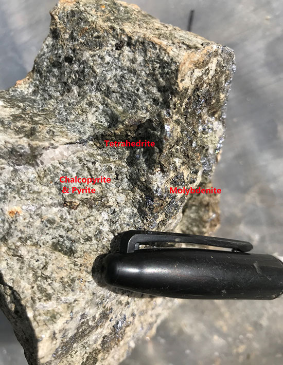
Figure 7. Granite rock sample within the contact/fault shear zone with chalcopyrite, pyrite, tetrahedrite and molybdenite minerals at NATMR006, Netalzul Mountain
A total of 74 rock samples and 362 soil samples (Figure 1) have been collected this field season from Netalzul Mountain. The assay results for a portion of those samples were released August 25th, 2020 (https://bit.ly/321lMLb).
Rock and Soil Sampling and Analytical Procedures
Rock samples were either chip or grab samples taken directly from the field. Multiple clean rock surfaces were chosen to analyze the major metallic elements (Cu, Pb, Zn, Ag, Mo, Sb and W) via PXRF (Portable Niton XL3t GOLDD+ XRF X-Ray Fluorescence Analyzer).
Soil samples were taken on a 50 m by 50 m grid along the contact/fault shear zone at the artisanal workings area. Approximately 200 g to 300 g of soil was sampled at a depth of approximately 25-30 cm from surface. Soil sampling primarily targeted the B horizon where appropriate, and samples were collected in labelled craft paper bags. Soil samples were analyzed via PXRF (Portable Thermo Scientific Niton XL3t GOLDD+ X-Ray Fluorescence Analyzer) for Cu, Pb, Zn, Ag, Mo, Sb and W.
All work was conducted by the Company’s team of qualified geologists.
Qualified Person
Yingting (Tony) Guo, P.Geo., President of Jaxon Mining Inc., a Qualified Person as defined by National Instrument 43-101, has reviewed and prepared the scientific and technical information and verified the data supporting such scientific and technical information contained in this news release.
About Jaxon Mining Inc.
Jaxon is a precious and base metals exploration company with a regional focus on Western Canada. The Company is currently focused on advancing the Red Springs Project at its 466 km2 Hazelton Property located near Smithers in northwestern British Columbia. In addition to Red Springs, Hazelton hosts three other areas of interest (AOIs): Blunt Mountain, Max and Netalzul Mountain. For more information, please visit https://jaxonmining.com.
ON BEHALF OF THE BOARD OF DIRECTORS
JAXON MINING INC.
“John King Burns“
John King Burns, Chairman