

SASKATOON, SK – April 12, 2022 – Omineca Mining and Metals Ltd (TSXV: OMM) (“Omineca” or the “Company”) announces that it has acquired an additional 10,176 hectares (101.76 sq kms) of mineral claims within and adjacent to the Company’s Wingdam exploration ground (see figure 1) located in the Cariboo Mining District in South Central British Columbia. The newly staked claims extend the property along the geological trend running northwest and southeast of Omineca’s Wingdam underground Paleoplacer project. Programs for Mary Creek (northwest of Wingdam) and Skopos (south of Wingdam) target areas are currently being finalized for a spring drill campaign. Several other exploration programs including ground-based geophysics (Induced Polarization), Mobile Metal Ion Analysis and structural mapping are ongoing along trend to the southeast, as well as along a parallel trend located southwest of Wingdam. Program details, including drill plans, will be announced once finalized.
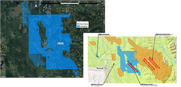
The 10,176 hectares of newly acquired mineral tenures brings Omineca’s land position to 65,218 Hectares (652.2 sq kms) of exploration land bordered to the east and southwest by Osisko Development Corp.
Omineca’s land encompasses a series of northwest-southeast geological trends along and parallel to the Wingdam trend (see figure 1 inset). Some highlights of the new claims include:
- Claims located approximately 5 km southwest of Wingdam comprise a package within the Nicola suite of volcanic and sedimentary rocks and encompasses the Spanish thrust fault which runs adjacent to the Wingdam Trend and the Eureka thrust fault.
- A new claim set on the northern end of the Company’s land package extends the northwest trending Eureka thrust fault and the Wingdam trend and shows a high level of tectonic activity interpreted from geophysical surveys.
- Based on regional geophysics, the new southern claims extend the Wingdam trend, including the Spanish thrust fault to the southeast.
- Land staked to the southwest has had historic sampling with elevated gold values and falls within the northwest-southeast trending Quesnella Terrane which is host to the prolific gold-copper porphyry belt that includes Mt. Polly and Mt. Milligan mines and the Omineca/Canalaska Mouse Mountain project JV.
Work and exploration programs will be announced as each are developed.
Qualified Person
All scientific and technical information in this news release has been prepared or approved by Stephen Kocsis, P.Geo., Lead Geologist. Mr. Kocsis is a qualified person for the purposes of National Instrument 43-101 – Standards of Disclosure for Mineral Projects.
About Omineca Mining and Metals Ltd.
Omineca Mining and Metals Ltd.’s flagship Wingdam gold exploration and placer recovery project is located along the Barkerville Highway 45 km east of the town of Quesnel. The Wingdam Property includes mineral tenures totaling over 65,218 hectares (652 square kms) and in excess of 15 linear kilometers of placer claims, both encompassing the Lightning Creek valley where topographic conditions created thick layers of overburden, which preserved a large portion of a buried paleochannel containing placer gold-bearing gravels. Omineca also has an active geological program currently underway exploring for the potential multiple hard rock sources of the placer gold at Wingdam.
For further information, please contact:
Tom MacNeill
President and CEO
306-653-2692