Happy Creek Appoints Jason Bahnsen as President and CEO
May 1, 2024, Vancouver, British Columbia – Happy Creek Minerals Ltd. (TSX-V: HPY) (“Happy Creek” or the “Company”) is pleased to announce the appointment of Jason Bahnsen to the role

May 1, 2024, Vancouver, British Columbia – Happy Creek Minerals Ltd. (TSX-V: HPY) (“Happy Creek” or the “Company”) is pleased to announce the appointment of Jason Bahnsen to the role
April 23, 2024, Vancouver, British Columbia – Happy Creek Minerals Ltd. (TSX-V: HPY) (“Happy Creek” or the “Company”) is pleased to announce that it has executed a Binding Letter of
March 11, 2024, Vancouver, British Columbia – Happy Creek Minerals Ltd. (TSX-V: HPY) (“Happy Creek” or the “Company”) is pleased to announce the results of field work and geophysical modelling
Vancouver, April 18, 2024 – FPX Nickel Corp. (TSX-V: FPX, OTCQB: FPOCF) (“FPX” or the “Company”) is pleased to announce an expansion of the Company’s Global Generative Alliance (the “Generative
Two B.C. jade miners who were evicted from Tahltan traditional territory in 2020 are suing the B.C. government for wrongful expropriation of their mineral claims and seeking compensation for their
Vancouver, April 4, 2024 – FPX Nickel Corp. (TSX-V: FPX, OTCQB: FPOCF) (“FPX” or the “Company”) is pleased to announce the creation of a Technical Advisory Committee (“TAC”) to provide

Calgary, Alberta–(Newsfile Corp. – March 12, 2024) – Canadian Critical Minerals Inc. (TSXV: CCMI) (OTCQB: RIINF) (“CCMI” or the “Company“) is pleased to report that it has received additional revenues
Vancouver, March 5, 2024 – FPX Nickel Corp. (TSX-V: FPX, OTCQB: FPOCF) (“FPX” or the “Company”) is pleased to outline plans for advancement of the Baptiste Nickel Project (“Baptiste” or
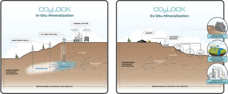
Vancouver, February 20, 2024 – FPX Nickel Corp. (TSX-V: FPX, OTCQB: FPOCF) (“FPX” or the “Company”) is pleased to provide an update on the activities of CO2 Lock Corp. (“CO2
February 12, 2024, Vancouver, British Columbia – Happy Creek Minerals Ltd. (TSX-V: HPY) (“Happy Creek” or the “Company”) is pleased to provide a corporate update including changes to management. The
May 1, 2024, Vancouver, British Columbia – Happy Creek Minerals Ltd. (TSX-V: HPY) (“Happy Creek” or the “Company”) is pleased to announce the appointment of Jason Bahnsen to the role
April 23, 2024, Vancouver, British Columbia – Happy Creek Minerals Ltd. (TSX-V: HPY) (“Happy Creek” or the “Company”) is pleased to announce that it has executed a Binding Letter of
March 11, 2024, Vancouver, British Columbia – Happy Creek Minerals Ltd. (TSX-V: HPY) (“Happy Creek” or the “Company”) is pleased to announce the results of field work and geophysical modelling
Vancouver, April 18, 2024 – FPX Nickel Corp. (TSX-V: FPX, OTCQB: FPOCF) (“FPX” or the “Company”) is pleased to announce an expansion of the Company’s Global Generative Alliance (the “Generative
Two B.C. jade miners who were evicted from Tahltan traditional territory in 2020 are suing the B.C. government for wrongful expropriation of their mineral claims and seeking compensation for their
Vancouver, April 4, 2024 – FPX Nickel Corp. (TSX-V: FPX, OTCQB: FPOCF) (“FPX” or the “Company”) is pleased to announce the creation of a Technical Advisory Committee (“TAC”) to provide
Calgary, Alberta–(Newsfile Corp. – March 12, 2024) – Canadian Critical Minerals Inc. (TSXV: CCMI) (OTCQB: RIINF) (“CCMI” or the “Company“) is pleased to report that it has received additional revenues
Vancouver, March 5, 2024 – FPX Nickel Corp. (TSX-V: FPX, OTCQB: FPOCF) (“FPX” or the “Company”) is pleased to outline plans for advancement of the Baptiste Nickel Project (“Baptiste” or
Vancouver, February 20, 2024 – FPX Nickel Corp. (TSX-V: FPX, OTCQB: FPOCF) (“FPX” or the “Company”) is pleased to provide an update on the activities of CO2 Lock Corp. (“CO2
February 12, 2024, Vancouver, British Columbia – Happy Creek Minerals Ltd. (TSX-V: HPY) (“Happy Creek” or the “Company”) is pleased to provide a corporate update including changes to management. The